
Jo is doing most of the heavy lifting in terms of preparation, what with paperwork, the airplane, and all of the details that go along with that. For that, I am very grateful. She's made it easy on me! I practically just have to show up at the airport with my flight bag and a smile on my face.
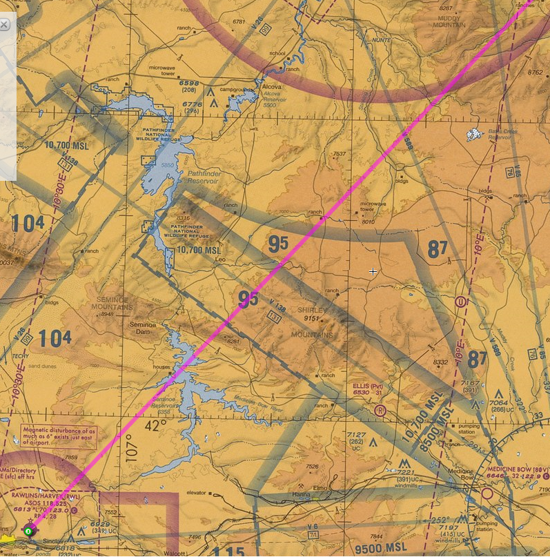 We still haven't hammered out exactly how we're going to do a piece of the race, specifically the chunk between Spearfish and Rawlins. I think we've got a pretty good idea, but to give you an idea of what we're seeing, I've stuck a piece of the sectional here for you to look at. That line is the direct line. For the non-aviation folks out there, the two or three digit blue numbers are the tallest obstacles in that sector, times 100 in feet mean sea level. So 87 is really 8,700 feet. There is some tall stuff out there! We want to go direct as possible, but we don't want to hit anything hard, either. I think we have an amicable solution. I might post it at a later date, or what we ended up flying. Things can still change!
Oddly enough, according to the sectional, there are quite a few sand dunes out along that route. I've never been out there, so it's a weird visual to picture sand dunes in the Rockies. I'll be sure to keep my eyes peeled and take lots of pictures. Oh, and I think I'll have a fun game for us to play in flight. We're going to play "spot the ranch," since those seem to be the only things out along that piece of route (that are marked on the sectional at least). There are a few windmills charted, and a few pumping stations, but that's about it. I guess we'll see what's out there!
No comments:
Post a Comment